| Prepare a scale drawing showing the relative sizes of the highest mountain as compared with the earth's diameter.
3. Project For Bulletin Board Display
Locate some mountain ranges of the earth.
Suggested Format
NAME TYPE LOCATION
Mt. Krakatoa Volcanic Indonesia
Rocky Mountains Fold USA
Alps Fold Switzerland
4. Using a large "world" outline map, mark the location of the major mountain ranges of the earth.
5. Do you live in a mountainous area? How were these mountains formed?
RESEARCH REPORT FOR THE ADVANCED PUPIL: The effect of mountains on the development of our civilization. (For example: mountain ranges are natural boundaries, which restricted travel to and from mountainous areas, etc.)
EARTHQUAKES
Earthquakes and volcanoes occur due to internal forces of the earth. The central part of the earth is very hot. Due to this the minerals remain in a molten (plastic state) called magma. When water penetrates through the cracks of fissures of the earth they turn to vapour because of the internal heat. This vapour exerts tremendous pressure upward and tries to release the pressure formed. This release of pressure causes a lot of energy to be released and a series of waves are started which travel away from the break through the earth to cause earthquakes. The earthquake is a vibration of the earth caused by the waves that travel through it.
The movements, which cause earthquakes, take place along faults. Earthquake zones occur along the coastal areas surrounding the Pacific and Indian Oceans. |
SUGGESTED ACTIVITIES
1. Research Report: The seismograph: its uses. Include (1) How a seismograph is used to determine the location and intensity of earthquakes; (2) As an aid in determining the interior composition of the earth; (3) As an aid in the location of oil deposits.
2. Locate the earthquake belt (regions) of the earth on a "world" map.
3. Have your students shade in the earthquake belt (region) on a blank outline "world" map. Have them identify those countries (and states) located in the earthquake belt.
4. Locate and identify those places on the earth where major earthquakes have occurred. For example:
a. 1906 - San Francisco, USA
b. 1920 - Kwanto Province,
Japan (almost 150,000 dead)
c. 1960 - Agadir, Morocco (12,000 dead)
d. 1960 - Chile (5,000 dead)
e. 1962 - Iran (10,000 dead)
f. 1964 - Alaska
g. 1985 - Mexico
h. 1991 - Uttarkashi, UP, India
i. 1993 - Latur, Maharashtra, India
i. 1995 - Kobe, Japan
j. 1997 - Jabalpur, MP, India
k. 1999 - Chamoli, UP, India
j. 2001 - Bhuj, Gujarat, India.
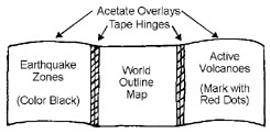
5. Project: Construct an acetate overlay showing the earthquake belt and location of some important volcanoes. Is there a correlation between the location of these volcanoes and the location of the earthquake belt?

|

